Guidance and Orientation in Open World Maps.

As I was stating before, level design in general and open world level design in particular is often based on 3 pillars:
- Guidance — Player orientation
- Challenge — Skill Testing
- Immersion — Storytelling and keeping the player in the flow

These pillars communicate with each other giving birth to the game-play experience.
If we were to remove one of them, we would get into an incomplete chain that would lead to some of the following side effects:
- Player confusion — Don’t know where to go or what to do.
- Lack of flavor — The game seems flat. There is enough challenge and enough guidance but there is no context.
- No Challenge — The guidance is great, the immersion is there but the game is boring, game-play wise it’s always the same.
The point of this article is to frame the concept of guidance a little better and to determine how we can improve guidance in our open world games.
Mind Mapping
Let’s consider a simple orientation exercise:
Context:
- Every day of your life you wake up and you go somewhere (work, school, shopping, etc).
Question:
- How do we get there?
- If we were to actually draft a list of instructions in relation to how other people could get there how would we do it?
- What sort of details would we focus on?
- What would be the key elements in our instructions?

Answer:
We would probably try to articulate a response based on the following formula:
- Action+Direction+Landmark.
Example:
- Go straight ahead till you see the Kings Statue.
More complicated directions could include multiple steps:
- Go straight ahead till you get to the pub
- Take a left and walk until you reach the intersection
- Cross the street and take a right at the old oak tree
- Look to your left.
This kind of orientation comes from the fact that, as living beings, we are able to signpost locations in the real world in order to use them as orientation factors when we are trying to reach a goal.
We hang on to the recognizable in order to figure out how to get where we want to go there.
For example (and with this occasion here’s a tour of Bucharest):
- Say we are at Kulturhaus in Bucharest
- We have to give directions to somebody for them to reach the Mantuleasa Church.

We could arbitrarily draw a line on the map and tell them to follow it.

But with some many turns and twists it’s kind hard to actually prevent people from getting lost using this method.
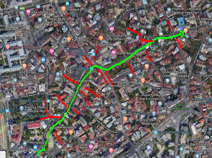
So we can try to be more specific about it:
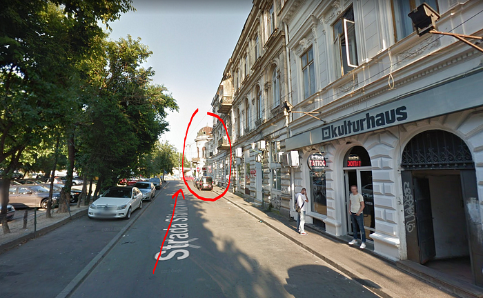
- Go straight until you reach that domed building

- Take a left when at the intersection

- Follow the tram lines till you see the building at the end of the street. There will be some construction on the right.

- When you reach that building the street will fork. Go to the right now on the left and keep going. There will be some apartment buildings on the right.
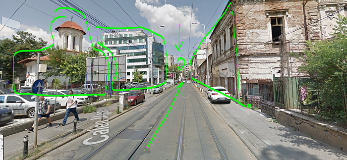
- Past this point there will be a church on your left and modern building next to it. On the right you will see a lot of old houses. Go straight until you reach an intersection with a multi level apartment building in the middle.

- Once you get there go right pass the white house.

- Take a left pass the white house before reaching the park ahead.

- Go straight past the large trees

- At some point there will be a large apartment building on the left that leads into an intersection.

- You will know that you are on the right path if you see a green fence and a bunch of houses in the background. Go right!
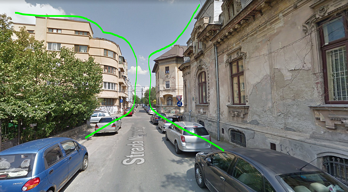
- At this point you will find your self between an old apartment building on the left (from the Dej era) and some mid 19-th century houses on the right.

Keep going straight and destination will be revealed to you.
Please note that I drew on these pictures just to pinpoint what the orientation factors could be in the environment. What sort of buildings you might use as signposting in the environment.
So with all this said and done we get this:

And we can also further simplify this since we are no longer bound to the reality at this point.
The reason we are divorcing ourselves from reality is because each concept in the list above can be interpreted in many ways, so we need to find a structure that is free of form, so we can focus on function. We are aiming at the essence of this entire process.

Now we have a stable structure that is supposed to keep you on track when trying to reach the Targeted church.
Note! Although it may look like it it, this structure is not linear and should not be threaten as such.

The purpose of doing this is so we can establish a clear set of guide lines and landmarks that will help with Orientation.

Now we can try to established a more stylized version of this map that does not contain all the bloat that we can see in the open world.
At this stage I can take the liberty to add a bunch of filler shapes inside the map to fill frame the streets properly:

Overlaying the concept locations over this would lead to something like this:

We can then choose to take this further and mark the intersections with proper landmark shapes so they contrast from the rest of the fillers:
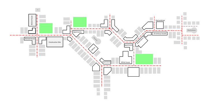
At this point we can get rid of the axes, adjust the scale and focus on the landmark hubs:
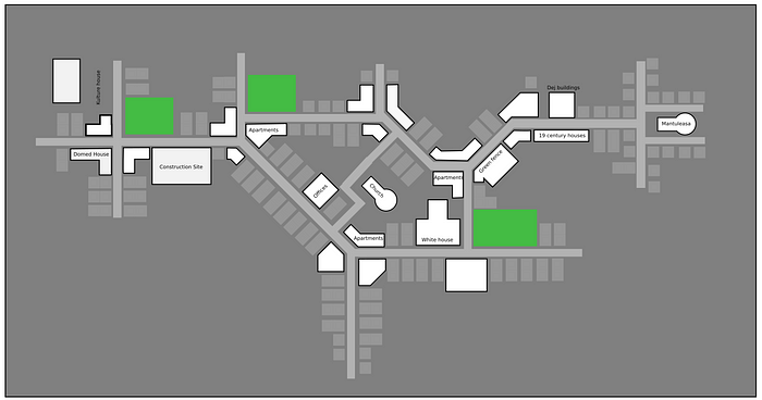
Landmarks don’t have to be super fantastical in their execution. They just need to stand out from the rest of the stuff:

Landmark hubs usually mark major path intersections and allow you see at least another hub in close proximity.
The landmarks are marked in white, the filler buildings are marked in gray and the hubs are marked in pink and tie to other hub via Line of site.
This process:
- Organize the world better
- Keeps you focused on what you actually want to have in the world
- Keeps size and proportions in check so you won’t build things that are bigger then they need to be.
Here’s a 3d representation:

There should be a visual mind mapping network being established in your map.

Some rules of thumb that I use in my work that seem to work:
- You need to be able to identify a landmark from any point in the map.
- Each Landmark needs to be part of a hub or intersection
- You should see at least 2 other landmarks from any hub/intersection
Also, as I was saying in the previous blog these locations should provide some sort of reward for the player. These places should contain most of the game-play in your map.
